- Burma
-
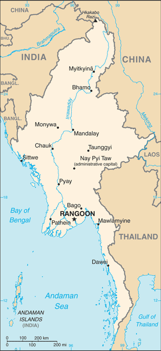 Introduction ::BurmaBackground:Various ethnic Burmese and ethnic minority city-states or kingdoms occupied the present borders through the 19th century. Over a period of 62 years (1824-1886), Britain conquered Burma and incorporated the country into its Indian Empire. Burma was administered as a province of India until 1937 when it became a separate, self-governing colony; in 1948, Burma attained independence from the Commonwealth. Gen. NE WIN dominated the government from 1962 to 1988, first as military ruler, then as self-appointed president, and later as political kingpin. In response to widespread civil unrest, NE WIN resigned in 1988, but within months the military crushed student-led protests and took power. Multiparty legislative elections in 1990 resulted in the main opposition party - the National League for Democracy (NLD) - winning a landslide victory. Instead of handing over power, the junta placed NLD leader (and Nobel Peace Prize recipient) AUNG SAN SUU KYI (ASSK) under house arrest from 1989 to 1995, 2000 to 2002, and from May 2003 to November 2010. In late September 2007, the ruling junta brutally suppressed protests over increased fuel prices led by prodemocracy activists and Buddhist monks, killing at least 13 people and arresting thousands for participating in the demonstrations. In early May 2008, Burma was struck by Cyclone Nargis, which left over 138,000 dead and tens of thousands injured and homeless. Despite this tragedy, the junta proceeded with its May constitutional referendum, the first vote in Burma since 1990. Parliamentary elections held in November 2010, considered flawed by many in the international community, saw the ruling Union Solidarity and Development Party garner over 75% of the seats. Parliament convened in January 2011 and selected former Prime Minister THEIN SEIN as president. Although the vast majority of national-level appointees named by THEIN SEIN are former or current military officers, the government has initiated a series of political and economic reforms leading to a substantial opening of the long-isolated country. These reforms have included allowing ASSK to contest parliamentary by-elections on 1 April 2012, releasing hundreds of political prisoners, reaching preliminary peace agreements with 10 of the 11 major armed ethnic groups, enacting laws that provide better protections for basic human rights, and gradually reducing restrictions on freedom of the press, association, and civil society. At least due in part to these reforms, ASSK now serves as an elected Member of Parliament and chair of the Committee for Rule of Law and Tranquility. Most political parties have begun building their institutions in preparation for the next round of general elections in 2015. The country is preparing to chair the Association of Southeast Asian Nations (ASEAN) in 2014.Geography ::BurmaLocation:Southeastern Asia, bordering the Andaman Sea and the Bay of Bengal, between Bangladesh and ThailandGeographic coordinates:22 00 N, 98 00 EArea:total: 676,578 sq kmcountry comparison to the world: 40land: 653,508 sq kmwater: 23,070 sq kmArea - comparative:slightly smaller than TexasLand boundaries:total: 5,876 kmborder countries: Bangladesh 193 km, China 2,185 km, India 1,463 km, Laos 235 km, Thailand 1,800 kmCoastline:1,930 kmMaritime claims:territorial sea: 12 nmcontiguous zone: 24 nmexclusive economic zone: 200 nmcontinental shelf: 200 nm or to the edge of the continental marginClimate:tropical monsoon; cloudy, rainy, hot, humid summers (southwest monsoon, June to September); less cloudy, scant rainfall, mild temperatures, lower humidity during winter (northeast monsoon, December to April)Terrain:central lowlands ringed by steep, rugged highlandsElevation extremes:lowest point: Andaman Sea 0 mhighest point: Hkakabo Razi 5,881 mNatural resources:petroleum, timber, tin, antimony, zinc, copper, tungsten, lead, coal, marble, limestone, precious stones, natural gas, hydropowerLand use:arable land: 15.94%permanent crops: 2.16%other: 81.89% (2011)Irrigated land:21,100 sq km (2004)Total renewable water resources:1,168 cu km (2011)Freshwater withdrawal (domestic/industrial/agricultural):total: 33.23 cu km/yr (10%/1%/89%)per capita: 728.6 cu m/yr (2005)Natural hazards:destructive earthquakes and cyclones; flooding and landslides common during rainy season (June to September); periodic droughtsEnvironment - current issues:deforestation; industrial pollution of air, soil, and water; inadequate sanitation and water treatment contribute to diseaseEnvironment - international agreements:party to: Biodiversity, Climate Change, Climate Change-Kyoto Protocol, Desertification, Endangered Species, Law of the Sea, Ozone Layer Protection, Ship Pollution, Tropical Timber 83, Tropical Timber 94signed, but not ratified: none of the selected agreementsGeography - note:strategic location near major Indian Ocean shipping lanesPeople and Society ::BurmaNationality:noun: Burmese (singular and plural)adjective: BurmeseEthnic groups:Burman 68%, Shan 9%, Karen 7%, Rakhine 4%, Chinese 3%, Indian 2%, Mon 2%, other 5%Languages:Burmese (official)note: minority ethnic groups have their own languagesReligions:Buddhist 89%, Christian 4% (Baptist 3%, Roman Catholic 1%), Muslim 4%, Animist 1%, other 2%Population:55,167,330 (July 2013 est.)country comparison to the world: 24note: estimates for this country take into account the effects of excess mortality due to AIDS; this can result in lower life expectancy, higher infant mortality, higher death rates, lower population growth rates, and changes in the distribution of population by age and sex than would otherwise be expectedAge structure:0-14 years: 26.7% (male 7,514,233/female 7,227,893)15-24 years: 18.6% (male 5,183,653/female 5,060,385)25-54 years: 42.8% (male 11,724,297/female 11,879,420)55-64 years: 6.7% (male 1,754,397/female 1,963,051)65 years and over: 5.2% (male 1,244,758/female 1,615,243) (2013 est.)Dependency ratios:total dependency ratio: 43.1 %youth dependency ratio: 35.7 %elderly dependency ratio: 7.5 %potential support ratio: 13.4 (2013)Median age:total: 27.6 yearsmale: 27 yearsfemale: 28.2 years (2013 est.)Population growth rate:1.05% (2013 est.)country comparison to the world: 110Birth rate:18.89 births/1,000 population (2013 est.)country comparison to the world: 97Death rate:8.05 deaths/1,000 population (2013 est.)country comparison to the world: 96Net migration rate:-0.3 migrant(s)/1,000 population (2013 est.)country comparison to the world: 124Urbanization:urban population: 32.6% of total population (2011)rate of urbanization: 2.49% annual rate of change (2010-15 est.)Major urban areas - population:RANGOON (capital) 4.259 million; Mandalay 1.009 million; Nay Pyi Taw 992,000 (2009)Sex ratio:at birth: 1.06 male(s)/female0-14 years: 1.04 male(s)/female15-24 years: 1.02 male(s)/female25-54 years: 0.99 male(s)/female55-64 years: 0.9 male(s)/female65 years and over: 0.77 male(s)/femaletotal population: 0.99 male(s)/female (2013 est.)Maternal mortality rate:200 deaths/100,000 live births (2010)country comparison to the world: 53Infant mortality rate:total: 46.31 deaths/1,000 live birthscountry comparison to the world: 46male: 52.91 deaths/1,000 live birthsfemale: 39.31 deaths/1,000 live births (2013 est.)Life expectancy at birth:total population: 65.6 yearscountry comparison to the world: 170male: 63.24 yearsfemale: 68.09 years (2013 est.)Total fertility rate:2.21 children born/woman (2013 est.)country comparison to the world: 102Contraceptive prevalence rate:46% (2009/10)Health expenditures:2% of GDP (2010)country comparison to the world: 190Physicians density:0.46 physicians/1,000 population (2008)Hospital bed density:0.6 beds/1,000 population (2006)Drinking water source:improved:urban: 93% of populationrural: 78% of populationtotal: 83% of populationunimproved:urban: 7% of populationrural: 22% of populationtotal: 17% of population (2010 est.)Sanitation facility access:improved:urban: 83% of populationrural: 73% of populationtotal: 76% of populationunimproved:urban: 17% of populationrural: 27% of populationtotal: 24% of population (2010 est.)HIV/AIDS - adult prevalence rate:0.6% (2009 est.)country comparison to the world: 64HIV/AIDS - people living with HIV/AIDS:240,000 (2009 est.)country comparison to the world: 24HIV/AIDS - deaths:18,000 (2009 est.)country comparison to the world: 17Major infectious diseases:degree of risk: very highfood or waterborne diseases: bacterial and protozoal diarrhea, hepatitis A, and typhoid fevervectorborne diseases: dengue fever, malaria, and Japanese encephalitiswater contact disease: leptospirosisanimal contact disease: rabiesnote: highly pathogenic H5N1 avian influenza has been identified in this country; it poses a negligible risk with extremely rare cases possible among US citizens who have close contact with birds (2013)Obesity - adult prevalence rate:4% (2008)country comparison to the world: 172Children under the age of 5 years underweight:22.6% (2010)country comparison to the world: 26Education expenditures:0.8% of GDP (2011)country comparison to the world: 172Literacy:definition: age 15 and over can read and writetotal population: 92.7%male: 95.1%female: 90.4% (2011 est.)School life expectancy (primary to tertiary education):total: 9 years (2007)Government ::BurmaCountry name:conventional long form: Union of Burmaconventional short form: Burmalocal long form: Pyidaungzu Myanma Naingngandaw (translated by the US Government as Union of Myanma and by the Burmese as Union of Myanmar)local short form: Myanma Naingngandawformer: Socialist Republic of the Union of Burmanote: since 1989 the military authorities in Burma, and the current parliamentary government, have promoted the name Myanmar as a conventional name for their state; the US Government has not adopted the name, which is a derivative of the Burmese short-form name Myanma NaingngandawGovernment type:parliamentary government took power in March 2011Capital:name: Rangoon (Yangon)geographic coordinates: 16 48 N, 96 09 Etime difference: UTC+6.5 (11.5 hours ahead of Washington, DC during Standard Time)note: Nay Pyi Taw is the administrative capitalAdministrative divisions:7 regions (taing-myar, singular - taing) and 7 states (pyi ne-myar, singular - pyi ne)regions: Ayeyarwady, Bago, Magway, Mandalay, Sagaing, Taninthayi, Yangonstates: Chin, Kachin, Kayah, Kayin, Mon, Rakhine (Arakan), Shanunion territory: Nay Pyi TawIndependence:4 January 1948 (from the UK)National holiday:Independence Day, 4 January (1948); Union Day, 12 February (1947)Constitution:approved by referendum 29 May 2008; reformed by a series of acts in 2011Legal system:mixed legal system of English common law (as introduced in codifications designed for colonial India) and customary lawInternational law organization participation:has not submitted an ICJ jurisdiction declaration; non-party state to the ICCtSuffrage:18 years of age; universalExecutive branch:chief of state: President THEIN SEIN (since 4 February 2011); Vice President SAI MOUK KHAM (since 3 February 2011); Vice President NYAN HTUN (since 15 August 2012)head of government: President THEIN SEIN (since 4 February 2011)cabinet: cabinet is appointed by the president and confirmed by the parliament(For more information visit the World Leaders website )elections: THEIN SEIN elected president by the parliament from among three vice presidents; the upper house, the lower house, and military members of the parliament each nominate one vice president (president serves a five-year term)Legislative branch:bicameral, consists of the House of Nationalities [Amyotha Hluttaw] (224 seats, 168 directly elected and 56 appointed by the military; members serve five-year terms) and the House of Representatives [Pythu Hluttaw] (440 seats, 330 directly elected and 110 appointed by the military; members serve five-year terms)elections: last held on 7 November 2010 (next to be held in December 2015)election results: House of Nationalities - percent of vote by party - USDP 74.8%, others (NUP, SNDP, RNDP, NDF, AMRDP) 25.2%; seats by party - USDP 129, others 39; House of Representatives - percent of vote by party - USDP 79.6%, others (NUP, SNDP, RNDP, NDF, AMRDP) 20.4%; seats by party - USDP 259, others 71Judicial branch:highest court(s): Supreme Court of the Union (consists of the chief justice and 7-11 judges)judge selection and term of office: chief justice and judges nominated by the president, with approval of the Pythu Hlattaw, and appointed by the president; judges normally serve until mandatory retirement at age 70subordinate courts: High Courts of the Region; High Courts of the State; Court of the Self-Administered Division; Court of the Self-Administered Zone; district and township courts; special courts (for juvenile, municipal, and traffic offenses); courts martialPolitical parties and leaders:All Mon Region Democracy Party or AMRDP [NAING NGWE THEIN]National Democratic Force or NDF [KHIN MAUNG SWE, Dr.THAN NYEIN]National League for Democracy or NLD [AUNG SAN SUU KYI]National Unity Party or NUP [TUN YE]Rakhine Nationalities Development Party or RNDP [Dr. AYE MG]Shan Nationalities Democratic Party or SNDP [SAI AIKE PAUNG]Shan Nationalities League for Democracy or SNLD [HKUN HTUN OO]Union Solidarity and Development Party or USDP [SHWE MANN, HTAY OO]numerous smaller partiesPolitical pressure groups and leaders:Thai border:Ethnic Nationalities Council or ENCFederation of Trade Unions-Burma or FTUB (exile trade union and labor advocates)National Coalition Government of the Union of Burma or NCGUB (self-proclaimed government in exile) [""Prime Minister"" Dr. SEIN WIN] consists of individuals, some legitimately elected to the People's Assembly in 1990 (the group fled to a border area and joined insurgents in December 1990 to form a parallel government in exile)National Council-Union of Burma or NCUB (exile coalition of opposition groups)United Nationalities Federal Council (UNFC)Inside Burma:Karen National Union or KNUKarenni National People's Party or KNPPUnited Wa State Army or UWSA88 Generation Students (pro-democracy movement)several other Chin, Karen, Mon, and Shan factionsnote: freedom of expression has been highly restricted in Burma; the restrictions are being relaxed by the government; political groups, other than parties approved by the government, are limited in numberInternational organization participation:ADB, ARF, ASEAN, BIMSTEC, CP, EAS, FAO, G-77, IAEA, IBRD, ICAO, ICRM, IDA, IFAD, IFC, IFRCS, IHO, ILO, IMF, IMO, Interpol, IOC, IOM, IPU, ISO (correspondent), ITU, ITUC (NGOs), NAM, OPCW (signatory), SAARC (observer), UN, UNCTAD, UNESCO, UNIDO, UNWTO, UPU, WCO, WHO, WIPO, WMO, WTODiplomatic representation in the US:chief of mission: Ambassador (vacant); Charge d'Affaires YE LWINchancery: 2300 S Street NW, Washington, DC 20008telephone: [1] (202) 332-3344FAX: [1] (202) 332-4351consulate(s) general: none; Burma has a Mission to the UN in New YorkDiplomatic representation from the US:chief of mission: Ambassador Derek J. MITCHELLembassy: 110 University Avenue, Kamayut Township, Rangoonmailing address: Box B, APO AP 96546telephone: [95] (1) 536-509, 535-756, 538-038FAX: [95] (1) 511-069Flag description:design consists of three equal horizontal stripes of yellow (top), green, and red; centered on the green band is a large white five-pointed star that partially overlaps onto the adjacent colored stripes; the design revives the triband colors used by Burma from 1943-45, during the Japanese occupationNational symbol(s):chinthe (mythical lion)National anthem:name: ""Kaba Ma Kyei"" (Till the End of the World, Myanmar)lyrics/music: SAYA TINnote: adopted 1948; Burma is among a handful of non-European nations that have anthems rooted in indigenous traditions; the beginning portion of the anthem is a traditional Burmese anthem before transitioning into a Western-style orchestrated workEconomy ::BurmaEconomy - overview:Burma is a resource-rich country but still suffers from pervasive government controls, inefficient economic policies, corruption, and rural poverty. Burma is the poorest country in Southeast Asia; approximately 32% of the population lives in poverty. Corruption is prevalent and significant resources are concentrated in the extractive industries are concentrated in a few hands. The Burmese government has initiated notable economic reforms. In October 2011, 11 private banks were allowed to trade foreign currency. On April 2, 2012, Burma's multiple exchange rates were abolished and the Central Bank of Myanmar established a managed float of the Burmese kyat. In November 2012, President THEIN SEIN signed a new Foreign Investment Law. Despite these reforms, the Burmese government has not yet embarked on broad-based macro-economic reforms or addressed key impediments to economic development such as Burma's opaque revenue collection system. Key benchmarks of economic progress would include steps to ensure the independence of the Central Bank, provide budget allocation for social services, and enact laws to protect intellectual and real property. In recent years, foreign investors have shied away from nearly every sector except for natural gas, power generation, timber, and mining. The exploitation of natural resources does not benefit the population at large. The most productive sectors will continue to be in extractive industries - especially oil and gas, mining, and timber - with the latter two causing significant environmental degradation. Other areas, such as manufacturing, tourism, and services, struggle in the face of poor infrastructure, unpredictable trade policies, undeveloped human resources (the result of neglected health and education systems), endemic corruption, and inadequate access to capital for investment. The US initially imposed sanctions on Burma in response to the 1988 military crackdown and the regime's refusal to honor the democratic opposition National League for Democracy's 1990 landslide election victory under the leadership of AUNG SAN SUU KYI. In 2003, the US moved from broad-based to more targeted sanctions. In July 2012, as a result of reforms undertaken by President THEIN SEIN and his nominally civilian government, the US broadly eased restrictions on new investment in and the export of financial services to Burma. In November 2012, the US eased the import bank on Burmese products to the US with the exception of jadeite and rubies. Although the Burmese government has good economic relations with its neighbors, significant improvements in economic governance, the business climate, and the political situation are needed to promote serious foreign investment.GDP (purchasing power parity):$90.93 billion (2012 est.)country comparison to the world: 77$85.54 billion (2011 est.)$81.11 billion (2010 est.)note: data are in 2012 US dollarsGDP (official exchange rate):$53.14 billion (2012 est.)GDP - real growth rate:6.3% (2012 est.)country comparison to the world: 425.5% (2011 est.)5.3% (2010 est.)GDP - per capita (PPP):$1,400 (2012 est.)country comparison to the world: 204$1,400 (2011 est.)$1,300 (2010 est.)note: data are in 2012 US dollarsGross national saving:13.3% of GDP (2012 est.)country comparison to the world: 11216% of GDP (2011 est.)19.9% of GDP (2010 est.)GDP - composition, by end use:household consumption: 79.6%government consumption: 3.7%investment in fixed capital: 16.3%investment in inventories: 0.3%exports of goods and services: 0.2%imports of goods and services: -0.2%(2012 est.)GDP - composition, by sector of origin:agriculture: 38.8%industry: 19.3%services: 41.8% (2012 est.)Agriculture - products:rice, pulses, beans, sesame, groundnuts, sugarcane; fish and fish products; hardwoodIndustries:agricultural processing; wood and wood products; copper, tin, tungsten, iron; cement, construction materials; pharmaceuticals; fertilizer; oil and natural gas; garments, jade and gemsIndustrial production growth rate:8.6% (2012 est.)country comparison to the world: 18Labor force:33.41 million (2012 est.)country comparison to the world: 19Labor force - by occupation:agriculture: 70%industry: 7%services: 23% (2001)Unemployment rate:5.4% (2012 est.)country comparison to the world: 515.5% (2011 est.)Population below poverty line:32.7% (2007 est.)Household income or consumption by percentage share:lowest 10%: 2.8%highest 10%: 32.4% (1998)Budget:revenues: $2.271 billionexpenditures: $4.487 billion (2012 est.)Taxes and other revenues:4.3% of GDP (2012 est.)country comparison to the world: 214Budget surplus (+) or deficit (-):-4.2% of GDP (2012 est.)country comparison to the world: 150Fiscal year:1 April - 31 MarchInflation rate (consumer prices):1.5% (2012 est.)country comparison to the world: 305% (2011 est.)Central bank discount rate:9.95% (31 December 2010 est.)country comparison to the world: 1812% (31 December 2009 est.)Commercial bank prime lending rate:13% (31 December 2012 est.)country comparison to the world: 3216.33% (31 December 2011 est.)Stock of narrow money:$11.54 million (31 December 2012 est.)country comparison to the world: 190$8.91 million (31 December 2011 est.)Stock of domestic credit:$15.66 billion (31 December 2011 est.)country comparison to the world: 90$11.83 billion (31 December 2010 est.)Market value of publicly traded shares:$NACurrent account balance:-$891.2 million (2012 est.)country comparison to the world: 108$96.1 million (2011 est.)Exports:$8.23 billion (2012 est.)country comparison to the world: 100$8.113 billion (2011 est.)note: official export figures are grossly underestimated due to the value of timber, gems, narcotics, rice, and other products smuggled to Thailand, China, and BangladeshExports - commodities:natural gas, wood products, pulses, beans, fish, rice, clothing, jade and gemsExports - partners:Thailand 40.5%, India 14.7%, China 14.2%, Japan 7.4% (2012)Imports:$7.477 billion (2012 est.)country comparison to the world: 109$5.921 billion (2011 est.)note: import figures are grossly underestimated due to the value of consumer goods, diesel fuel, and other products smuggled in from Thailand, China, Malaysia, and IndiaImports - commodities:fabric, petroleum products, fertilizer, plastics, machinery, transport equipment; cement, construction materials, crude oil; food products, edible oilImports - partners:China 37%, Thailand 20.2%, Singapore 8.7%, South Korea 8.7%, Japan 8.2%, Malaysia 4.6% (2012)Reserves of foreign exchange and gold:$7.551 billion (31 December 2012 est.)country comparison to the world: 79$7.017 billion (31 December 2011 est.)Debt - external:$5.614 billion (31 December 2012 est.)country comparison to the world: 118$7.766 billion (31 December 2011 est.)Exchange rates:kyats (MMK) per US dollar -853.476 (2012 est.)815 (2011 est.)5.58 (2010 est.)1,055 (2009)1,205 (2008)Energy ::BurmaElectricity - production:5.708 billion kWh (2009 est.)country comparison to the world: 113Electricity - consumption:3.794 billion kWh (2009 est.)country comparison to the world: 123Electricity - exports:0 kWh (2010 est.)country comparison to the world: 166Electricity - imports:0 kWh (2010 est.)country comparison to the world: 163Electricity - installed generating capacity:1.86 million kW (2009 est.)country comparison to the world: 103Electricity - from fossil fuels:67.7% of total installed capacity (2009 est.)country comparison to the world: 114Electricity - from nuclear fuels:0% of total installed capacity (2009 est.)country comparison to the world: 52Electricity - from hydroelectric plants:32.3% of total installed capacity (2009 est.)country comparison to the world: 69Electricity - from other renewable sources:0% of total installed capacity (2009 est.)country comparison to the world: 111Crude oil - production:20,200 bbl/day (2011 est.)country comparison to the world: 70Crude oil - exports:880 bbl/day (2009 est.)country comparison to the world: 65Crude oil - imports:0 bbl/day (2009 est.)country comparison to the world: 160Crude oil - proved reserves:50 million bbl (1 January 2012 est.)country comparison to the world: 79Refined petroleum products - production:16,700 bbl/day (2008 est.)country comparison to the world: 99Refined petroleum products - consumption:40,620 bbl/day (2011 est.)country comparison to the world: 107Refined petroleum products - exports:0 bbl/day (2008 est.)country comparison to the world: 155Refined petroleum products - imports:12,730 bbl/day (2008 est.)country comparison to the world: 126Natural gas - production:12.1 billion cu m (2010 est.)country comparison to the world: 38Natural gas - consumption:3.29 billion cu m (2010 est.)country comparison to the world: 70Natural gas - exports:8.81 billion cu m (2010 est.)country comparison to the world: 23Natural gas - imports:0 cu m (2010 est.)country comparison to the world: 163Natural gas - proved reserves:283.2 billion cu m (1 January 2012 est.)country comparison to the world: 40Carbon dioxide emissions from consumption of energy:12.8 million Mt (2010 est.)country comparison to the world: 94Communications ::BurmaTelephones - main lines in use:521,100 (2011)country comparison to the world: 96Telephones - mobile cellular:1.244 million (2011)country comparison to the world: 151Telephone system:general assessment: meets minimum requirements for local and intercity service for business and governmentdomestic: system barely capable of providing basic service; mobile-cellular phone system is grossly underdevelopedinternational: country code - 95; landing point for the SEA-ME-WE-3 optical telecommunications submarine cable that provides links to Asia, the Middle East, and Europe; satellite earth stations - 2, Intelsat (Indian Ocean) and ShinSat (2011)Broadcast media:government controls all domestic broadcast media; 2 state-controlled TV stations with 1 of the stations controlled by the armed forces; 2 pay-TV stations are joint state-private ventures; access to satellite TV is limited; 1 state-controlled domestic radio station and 9 FM stations that are joint state-private ventures; transmissions of several international broadcasters are available in parts of Burma; the Voice of America (VOA), Radio Free Asia (RFA), BBC Burmese service, the Democratic Voice of Burma (DVB), and Radio Australia use shortwave to broadcast in Burma; VOA, RFA, and DVB produce daily TV news programs that are transmitted by satellite to audiences in BurmaInternet country code:.mmInternet hosts:1,055 (2012)country comparison to the world: 172Internet users:110,000 (2009)country comparison to the world: 158Transportation ::BurmaAirports:64 (2013)country comparison to the world: 77Airports - with paved runways:total: 36over 3,047 m: 122,438 to 3,047 m: 111,524 to 2,437 m: 12under 914 m: 1 (2013)Airports - with unpaved runways:total: 28over 3,047 m: 11,524 to 2,437 m: 4914 to 1,523 m: 10under 914 m:13 (2013)Heliports:11 (2013)Pipelines:gas 3,739 km; oil 551 km (2013)Railways:total: 5,031 kmcountry comparison to the world: 36narrow gauge: 5,031 km 1.000-m gauge (2008)Roadways:total: 34,377 km (includes 358 km of expressways) (2010)country comparison to the world: 94Waterways:12,800 km (2011)country comparison to the world: 10Merchant marine:total: 29country comparison to the world: 86by type: cargo 22, passenger 2, passenger/cargo 3, specialized tanker 1, vehicle carrier 1foreign-owned: 2 (Germany 1, Japan 1)registered in other countries: 3 (Panama 3) (2010)Ports and terminals:major seaport(s): Moulmein, Sittweriver port(s): Rangoon (Rangoon River)Military ::BurmaMilitary branches:Myanmar Armed Forces (Tatmadaw): Army (Tatmadaw Kyi), Navy (Tatmadaw Yay), Air Force (Tatmadaw Lay) (2013)Military service age and obligation:18-35 years of age (men) and 18-27 years of age (women) for voluntary military service; no conscription (a 2010 law reintroducing conscription has not yet entered into force); service obligation 2 years; male (ages 18-45) and female (ages 18-35) professionals (including doctors, engineers, mechanics) serve up to 3 years; service terms may be stretched to 5 years in an officially declared emergency; Burma signed the Convention on the Rights of the Child (CRC) on 15 August 1991; on 27 June 2012, the regime signed a Joint Action Plan on prevention of child recruitment; in February 2013, the military formed a new task force to address forced child conscription, which reportedly continues (2013)Manpower available for military service:males age 16-49: 14,747,845females age 16-49: 14,710,871 (2010 est.)Manpower fit for military service:males age 16-49: 10,451,515females age 16-49: 11,181,537 (2010 est.)Manpower reaching militarily significant age annually:male: 522,478female: 506,388 (2010 est.)Military expenditures:4.8% of GDP (2012)country comparison to the world: 17Transnational Issues ::BurmaDisputes - international:over half of Burma's population consists of diverse ethnic groups who have substantial numbers of kin in neighboring countries; the Naf River on the border with Bangladesh serves as a smuggling and illegal transit route; Bangladesh struggles to accommodate 29,000 Rohingya, Burmese Muslim minority from Arakan State, living as refugees in Cox's Bazar; Burmese border authorities are constructing a 200 km (124 mi) wire fence designed to deter illegal cross-border transit and tensions from the military build-up along border with Bangladesh in 2010; Bangladesh referred its maritime boundary claims with Burma and India to the International Tribunal on the Law of the Sea; Burmese forces attempting to dig in to the largely autonomous Shan State to rout local militias tied to the drug trade, prompts local residents to periodically flee into neighboring Yunnan Province in China; fencing along the India-Burma international border at Manipur's Moreh town is in progress to check illegal drug trafficking and movement of militants; 140,000 mostly Karen refugees fleeing civil strife, political upheaval and economic stagnation in Burma live in remote camps in Thailand near the borderRefugees and internally displaced persons:IDPs: more than 454,200 (government offensives against armed ethnic minority groups near its borders with China and Thailand) (2012)stateless persons: 808,075 (2012); note - Burma's main group of stateless people is the Rohingya, Muslims living in northern Rakhine State; the Burmese Government does not recognize the Rohingya as a ""national race"" and stripped them of their citizenship under the 1982 Citizenship law, categorizing them as ""non-national"" or ""foreign residents""; native-born but non-indigenous people, such as Indians, and children born in Thailand to Burmese parents are also stateless; the Burmese Government does not grant citizenship to children born outside of the country to Burmese parents who left the country illegally or fled persecutionTrafficking in persons:current situation: Burma is a source country for women, children, and men trafficked for the purpose of forced labor, and for women and children subjected to sex trafficking in other countries; poor economic conditions have led to increased legal and illegal migration of Burmese adults and children throughout East Asia and parts of the Middle East, where they are subject to forced labor and sex trafficking; men are forced to work in the fishing and construction industries, while women and girls are forced into prostitution or domestic servitude; some Burmese economic migrants seeking work in Thailand are subsequently subjected to forced labor or sexual exploitation; military personnel and insurgent militias unlawfully conscript child soldiers and continue to be the leading perpetrators of forced labor inside the country; Burmese children are also forced to work in tea shops, home industries, on plantations, and as beggarstier rating: Tier 2 Watch List - Burma does not fully comply with the minimum standards for the elimination of trafficking, but it is making significant efforts to do so; anti-trafficking law enforcement efforts focus on the recruitment and transport of Burmese women and girls across international boundaries for forced marriages and sex trafficking; efforts to combat trafficking within Burma remain weak; forced labor of civilians and the recruitment of child soldiers by both military and private entities remain serious problems; the government continues modest efforts to provide temporary shelter and facilitate safe passage to Burmese victims repatriated from abroad, but its overall victim protection efforts are inadequate; in 2012, the government signed a UN-backed action plan for the identification, release, and rehabilitation of children in the Burmese military; as a result, some child soldiers have been released, but the government has not taken steps to prevent recruitment (2013)Illicit drugs:world's third largest producer of illicit opium with an estimated production in 2009 of 250 metric tons, a decrease of 27%, and poppy cultivation in 2009 totaled 17,000 hectares, a 24% decrease from 2008; production in the United Wa State Army's areas of greatest control remains low; Shan state is the source of 94.5% of Burma's poppy cultivation; lack of government will to take on major narcotrafficking groups and lack of serious commitment against money laundering continues to hinder the overall antidrug effort; major source of methamphetamine and heroin for regional consumption (2008)"
The World Factbook. 2014.